


Extreme Drought Conditions Continue
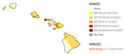
Sept. 15 Map courtesy of U.S. Drought Monitor
By Catherine Cluett Pactol
It comes as no surprise to many Molokai residents that the island is in a serious drought. With parts of Molokai suffering from conditions recently classified as extreme drought, farmers are and their crops are among those particularly affected.
According to the national U.S. Drought Monitor, with data updated on Sept. 15, the west end of Molokai is already indicated at D3, extreme drought category, and one of the only areas in Hawaii under than classification.
Those conditions will likely continue through the fall, stated an Aug. 20 outlook issued by NOAA Climate Prediction Center. Any rainfall that does occur will probably continue to favor the east-facing windward slopes, with leeward areas becoming drier.
“Based on the forecast, and barring any tropical cyclone near passes or direct hits, leeward dryness will likely persist, resulting in a potential worsening and expansion of current drought areas across the state into early fall before easing late in 2020,” the statement said.
Things may look up at the end of the year, however. The outlook projects a transition to above normal rainfall in late 2020. Experts are predicting higher than normal temperatures across the state through the rest of 2020 and into early 2021 due to the forecast of above average sea surface temperatures around the Hawaiian Islands.
A Sept. 9 Drought Information Statement issued by the National Weather Service Honolulu office said that parts of Maui County have been particularly hard hit.
“Ground observations from Molokai validated the poor vegetation health detected by satellite over the western half of the island,” stated the report.
Glenn Teves, UH College of Tropical Agriculture and Human Resources extension agent for Molokai, said farmers are left struggling to make adjustments and keep their crops alive.
“Farmers have had to adjust to climate change by fine tuning their nutrition programs and their water allocation to the crop and also how often they irrigate,” Teves said. “With these high temperatures, water is evaporating at high amounts exceeding 70,000 gallons per acre per week, so farmers have to compensate for these evaporation losses in addition to supplying water to the crop.”
Most crops don’t thrive in extremely hot, dry conditions, said Teves but those particularly suffering are papaya, taro and leafy vegetables.
The extreme conditions are also causing some plants to “crash.”
“At high temperatures, plants are growing so rapidly that they can’t take up enough water and nutrition to support good growth,” Teves continued. “In some cases the plants will crash by dropping flowers in the case of papaya and also tomato. Only a few crops can handle these extreme conditions if they have adequate water such as eggplant, okra, squash, watermelon and others, but in these kinds of conditions, insect populations can explode because they grow faster and complete life cycles faster under high temperatures.”
Teves said the “long term drought” conditions are made worse by several factors, like less trade winds, which can cause temperatures to exceed 90 degrees.
“The trades have a cooling effect and also bring morning and evening showers, and without it everything dries up and we experience temperatures above the norm,” he explained. “This also effects our water supply that’s replenished by trade showers in the mountains, so the aquifer is not being recharged at normal rates. You can see this along the coast with salt along the highway and in yards along the coast.”
The next long-lead outlook will be issued by the Climate Prediction Center on Sept. 17, and the next Drought Information Statement will be issued on Oct. 8, or sooner if necessary in response to significant changes in conditions, according to the National Weather Service.


Don't have a Molokai Dispatch ID?
Sign up is easy. Sign up now
You must login to post a comment.
Lost Password